| From: blowgunner
|
|
|
|
|
|
|
| Date: 08-Aug-17 |
|
I have received permission to hunt this property and I need some tips on what I should be looking for as far as where to begin scouting for stand and blind placement
|
|
| From: White Falcon
|
|
|
|
|
|
|
| Date: 08-Aug-17 |
|
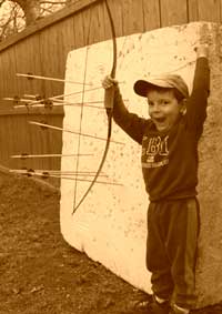
Opening at the bottom by red line!
|
|
| From: Thundermtn
|
|
|
|
|
|
|
| Date: 08-Aug-17 |
|
Do you hunt mornings or evenings? It's sort of set up for evenings. You be blowing scent into the bedding areas unless your real careful and are only hunting with a perfect wind. They'll be coming down in the evening, so will the thermals. A North wind is going to be your friend here except for a couple spots on the South end. Your best bet now is to get out there and scout food sources and oak flats that will let you get in without making everything on that hill go nocturnal.
|
|
| From: JustSomeDude
|
|
|
|
|
|
|
| Date: 08-Aug-17 |
|
Deer tend to follow the path of least resistance. I tend to find bedding areas 2/3 of the way up slopes or thick areas near clearings. If follow the funnels down, that's usually where trails will converge. You might follow one down to the edge of the clearing. There are prestaging areas they hang out in before coming out into the clearings. So you figure out how to ambush those trails
There will be trails at the ridges as well. Basic strategy is to set up close enough to bedding areas to increase your odds but obviously not TOO close.
|
|
| From: Thundermtn
|
|
|
|
|
|
|
| Date: 08-Aug-17 |
|
There will probably be a damn good buck that beds within 100 yards of top of hill where the circular 780' contour on the South end lays, and the ridge that runs North of there should be great for scrapes and bucks running up and down it scenting the ravine tops to the West for does as they come into season.
|
|
| From: blowgunner
|
|
|
|
|
|
|
| Date: 08-Aug-17 |
|
Forgot to mention it's all 15-20 year old pines and thick brush.
|
|
| From: George D. Stout
|
|
|

|
|
|
|
| Date: 08-Aug-17 |
|
Food, water, shelter. Just get out there and look. That little field area in the middle would peak my interest, but I would look it over as much as possible. If you're the only one in there, then just try to find some good trails coming from those ridges into the valleys.
|
|
| From: Thundermtn
|
|
|
|
|
|
|
| Date: 08-Aug-17 |
|
Ugh. We'll at least that narrows down food scources. You in a bait state?
|
|
| From: blowgunner
|
|
|
|
|
|
|
| Date: 08-Aug-17 |
|
I am but im not a real big fan of baiting. It is some of my extended family's land and the small open spot in the middle is usually planted with rye. I will be the only one hunting there this year but it will be my first time there
|
|
| From: DanaC
|
|
|
|
|
|
|
| Date: 08-Aug-17 |
|
Need to know what food/mast is there, also bedding cover
|
|
| From: George D. Stout
|
|
|
|
|
|
|
| Date: 08-Aug-17 |
|
We can simply guess. You just need to walk it good. Things change from year to year.
|
|
| From: Babysaph
|

|
|
|
|
|
|
| Date: 11-Aug-17 |
|
I would just walk the property and find where to put my stands.
|
|
| From: StikBow
|
|
|
|
|
|
|
| Date: 11-Aug-17 |
|
Maps are a great help in laying out a generalized plan, but, as stated, recon the area. Look for beds, scrapes, rubs and trails, maybe a shed from yesteryear. Food and water sources. Detail them on your map, then you get a great idea of generalized patterns. Actually seeing deer and plotting their beds and escape routes will put you in the string dropping mode. Playing chess with deer on their game board is what separates hunting from shooting. Good luck
|
|
| From: IslandSnapShooter
|
|
|
|
|
|
|
| Date: 11-Aug-17 |
|
I would say zoom out to a bigger map so that we can see what else is going on surrounding properties if they have crops or orchards or clearings
|
|
| From: George D. Stout
|
|
|
|
|
|
|
| Date: 11-Aug-17 |
|
Dan, download Google Earth and you can print a satellite photo of the area. USGS usually has topo maps you can download as well. Google topo maps.
|
|
| From: camodave
|
|
|
|
|
|
|
| Date: 11-Aug-17 |
|
As usual I agree with Mr. Stout. I am a ground hunter so I cover a lot of ground in the areas that I hunt. And there are simply no shortcuts. Get out there and put in the time to learn the property.
DDave
|
|
| From: EF Hutton
|
|
|
|
|
|
|
| Date: 12-Aug-17 |
|
For people who grew up on hunting with Topo maps 7.5 m series 1: 24,000 scale, we became very good at picking spots considering our knowledge of how deer use terrain. So much so, that modern satellite maps are less useful to us. Gen x and millineum gen maybe not. Maybe they know modern maps better.
Given your map , i cannot help much. My experience is in deep south swamps & deltas. In these areas, for me the topo is king. I would say you need to know the area's top food, and the doe group beds.
|
|
| From: EF Hutton
|
|
|
|
|
|
|
| Date: 12-Aug-17 |
|
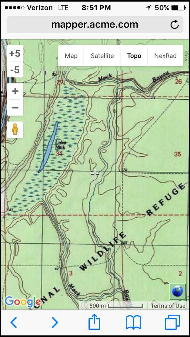
Here is an example of USGS Topo 7.5 minute
You see the swamp, 2 bayous with semi steep banks, and the many finger ridges petering out.
Those bayous likely hold water all summer, thus many oaks along them will most likely produce god acorns, having had water all summer.
Deer are edge animals. Look at the higher land along the swamp edge. Top right of the swamp is a high area with a stream finger off mack b, then another high land area. You can almost guarantee to find a good crossing there.
See the ridge tip petering out near an old road. Another feature to check, but food would dictate the first spots I would check. I would walk that secondary stream from the Nth bayou to the South bayou, and by the time I got South, I'd have more spots than I could hunt.
This is just an example. Maybe you can get a topo of this type for your area.
|
|
If you have already registered, please sign in now
For new registrations Click Here
|
|
|
|